
Roughly 500 geostationary satellites are currently placed in a static orbit (as viewed by a ground-based observer) about our planet at an
altitude ranging from 500 to 40,000 kilometers. The closest satellites orbitting the planet are believed to be spy satellites whereas most
distant are the geostationary group of satellites with an instrinsic magnitude of 11 or greater. As a result, due to their distance and faint
magnitude, geosats may be classified as the DSO's of the satellite world. At their high altitude not only can they virtually view the complete
globe below them but they also have the unique characteristic of having their orbital speed closely match the rotational speed of the earth
and, as such, give the impression to a ground-based observer of being stationary above the planet. These satellites have a wide range of
applications and functions and include remote sensing (Meteosat, GOES-East and GOES-West, GMS etc) and such telecommunication functions as
direct broadcast voice and video communications as well as live television coverage (Astra, Hot Bird, Telstar etc) by virtue of the fact they
can beam their signal from a "fixed" point in space relative to a ground source.
Note: The satellite constellation at 13.0° East is one of the most well-known fleets comprised of Hotbird 13A (aka
HB 6), Hotbird 13B (aka HB 8) and Hotbird 13C (aka HB 9). The fleet has a broad footprint covering Europe, Northern Africa and the Middle East
with services centered on both digital and high-definition television (1100 channels to 120 million homes) as well as radio and multimedia
services. Hotbird 13A (aka HB 6) was launched on August 28, 2002 from Cape Canaveral, Florida using an Atlas Centaur rocket, weighs 3.800 tons,
features 32 transponders (28 Ku- and 4 Ka-band) with an expected operational lifetime of twelve years. Hotbird 13B (aka HB 8) was launched on
August 4, 2006 from the Baikonur Cosmodrome in Kazakhstan using a Proton M rocket, weighs 4.875 tons, features 64 Ku-band transponders with a
planned operational lifetime of fifteen years. Finally, Hotbird 13C (aka HB 9) was launched on Dec 20, 2008 from Kourou, French Guyana using
an Ariane 5 ECA rocket, weighs 4.880 tons, features 64 Ku-band transponders and is expected to have an operational lifetime of fifteen years.
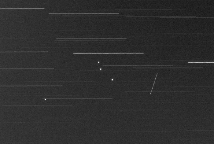
As revealed by the images below, a fourth geosat is parked in the immediate vicinity of the Hotbird fleet. More specifically, COMSATBw 2 (NORAD
ID: 36582) located at 13.2° East was launched on May 21, 2010 from Kourou, French Guyana using an Ariane 5 ECA rocket on behalf of Germany. Along
with COMSATbw-1 (NORAD ID: 35943 ) launched on September 30, 2009, these two (military) satellites provide a network for continuous communication
between the German government, its military authorities as well as its armed forces anywhere in the world. The satellite weighs 2.495 tons with
an expected lifetime of 15 years.
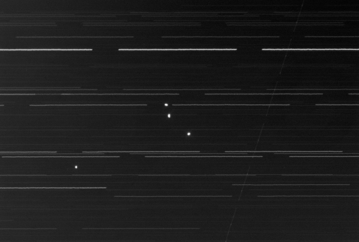
Note: The first image below represents a single one-minute exposure whereas the second image below is the sum of
the fifteen one-minute exposures captured and which reveals some very slight motion for the three Hotbird satellites during the approximate
20-minute span and which quite often is characteristic of geosats (ex. due to inclination).
|
NORAD ID: 27499 (13A), 29270 (13B), 33459 (13C) Common Name(s): Hotbird 13A/HB 6, Hotbird 13B/HB 8, Hotbird 13C/HB 9 Int Code: 2002-038A, 2006-032A, 2008-065D Location: 13.0° East Perigee: 35,300.5 - 35,776.5 km Apogee: 35,098.5 - 35,819.3 km Inclination: 0.0 - 4.5° Period: 1,436.0 min Launch Dates: Aug 28, 2002 (13A), Aug 04, 2006 (13B), Dec 20, 2008 (13C) Origin: EUTELSAT (Int) |
|
Date: Nov 02, 2012 23:14 - 23:32 UT+2 Location: Athens, Greece Equipment: AP 305/f3.8 Riccardi-Honders AP 1200GTO GEM SBIG ST-10XME SBIG CFW10 SBIG LRGB filters Integrations:
Image Scale: 1.21" per pixel Temperatures:
Software: CCDSoft V5.00.201 CCDStack V1.6.0.5 Photoshop CS5 |