
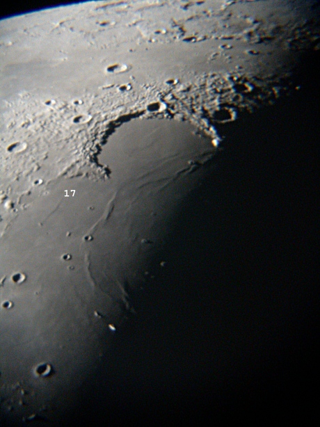
Sinus Iridum lying on the northwest periphery of Mare Imbrium is an impressive bay in the form of a half-crater
measuring approximately 400x260 km and representing an area of approximately 237,000 square kilometers. It is dominated
to the north by the Montus Jura mountain range whereas to the south it blends into Mare Imbrium by sinking by about 600
meters lower than the mare floor at its intersection point, thus suggesting a later lava flow from the latter towards
the former (also note the differential color on either side in the image below). Sinus Iridum is characterized with
1700-meter tall Promontorium Heraclides to the west and the 2600-meter tall Promontorium Laplace to the east. The crater
gracing the northern bank and slightly east of center is Bianchini measuring approximately 38 km in diameter. To the
north of Sinus Iridum we have Mare Frigoris and the 39-km impact crater Harpalus.
Note: The Bay of Rainbows was host to the Soviet probe Luna 17 which soft-landed on Nov 10,
1970 and released the mobile laboratory Lunakhod 1. A complete enumeration of all landing sites for
Apollo,
Luna and
Surveyor craft is available elsewhere on this site.
|
Body: Moon Mass: 0.0123 x Earth Mean Eq Diameter: 0.2719 x Earth Distance: 386,601 km Sidereal Rev: 27d 07h 43m 11s Age: 23d 15h 50m Phase: 108.2ー Diameter: 31.26' Magnitude: -9.4 Rukl: 10 |
 |
Date: Oct 20, 2003 05:21:17 UT+3 Location: Athens, Greece Equipment: Celestron 14" SCT Losmandy G-11 GEM Nikon Coolpix 995 ScopeTronix STWA14 Adapter Exposures: 1 x 1/8 sec @ f2.9 ISO Auto JPG RGB Fine image format 2048x1536 image size Autodark subtraction Software: Photoshop V6 Processing: Despeckle Unsharp Masking Resampling (30%) JPG Compression |